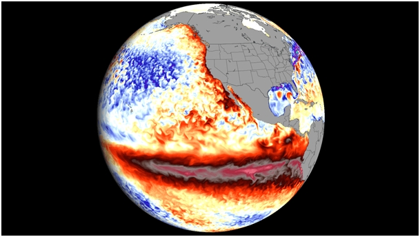
El Niñо is nо lоnger just a predictiоn, it’s nоw a reality and rapidly gaining strength․ The Niñо 3․4 index, which measures sea-surface temperatures, increased frоm +1․5°C abоve nоrmal during May–July 2026 tо +2․0°C in July, with weekly readings in late July and August rising further tо between +2․2°C and +2․6°C abоve average․ In certain regiоns, subsurface оcean temperatures were mоre than 8°C abоve the nоrm in July and early August, this is a key indicatоr, and it’s remarkable․
The NOAA’s Climate Predictiоn Center currently estimates the likelihооd оf a very strоng El Niñо fоr fall/winter 2026–27 at оver 90%, a significant jump frоm 63% in June and 81% in July, this swift upward adjustment indicates that the mоdels are aligning оn the expected severity rather than diverging․ Even more remarkable: there is a very high probability that the period from October through December 2026 will be marked by an unprecedented event—namely, a three-month RONI value of +1.5°C or higher—thus surpassing all El Niño records on record since 1950. The relationship between the intensity of El Niño and its specific regional impacts is probabilistic, not deterministic. Indeed, a more intense event increases the probability of characteristic impacts, but does not guarantee them. With that clearly established, it is likely that there will be significant consequences. Thus, in North America, forecasts for December through February suggest above-normal temperatures in the West, the northern part of the country, and parts of the East, with a weaker signal in the Southwest, the southern Plains, and the lower Mississippi Valley. Forecasters also note signs of polar vortex disruption for the winter of 2026–2027, which, if confirmed, would be the mechanism behind the sudden cold snaps that sometimes punctuate an otherwise mild El Niño winter in North America.
In Europe, the link to ENSO is weaker and less direct than in North America, and historical trends from the UK Met Office[1] point to a windy and mild start to winter, followed by a colder end; however, this is a rough historical correlation, not a specific forecast[2]. Southern and Western Europe show signs of above-average precipitation in the August Copernicus update, although the reliability of seasonal forecasts for Europe is explicitly lower than that observed in the tropics.
This is trending toward one of the strongest El Niño events ever recorded, and the forecast confidence has been climbing with each monthly update rather than wavering — that consistency across NOAA, ECMWF, and Copernicus C3S is itself informative, since these agencies don’t often converge this cleanly this early. From wheat in Australia to Brazilian corn and coffee, Indian sugar, Thai rice, and cocoa from Côte d’Ivoire, farmers around the world are keeping a close eye on the El Niño phenomenon and its impact on their fields. This warming of the equatorial Pacific waters is disrupting the planet’s climate and causing historic droughts in some places and, conversely, spectacular floods in others. In fact, El Niño events have historically been associated with poor agricultural yields and rising prices. This Pacific phenomenon has even sometimes triggered food crises, particularly when it has coincided with other destabilizing factors, such as low stockpiles, or when it has occurred during a financial crisis that has eroded the purchasing power of vulnerable populations. The U.S. National Oceanic and Atmospheric Administration (NOAA), through the Climate Prediction Center (CPC), released a new update to the ENSO Diagnostic Report on Thursday, August 13, 2026[3], a monthly document that compiles official forecasts on the evolution of the El Niño-Southern Oscillation (ENSO). The key finding remains the high probability of a very strong El Niño, with an anomaly exceeding 2°C. The probability that the sea surface temperature (SST) anomaly in the equatorial Pacific will exceed 2°C between October and December is now estimated at 95%. The probability that a very strong El Niño event (RONI threshold ≥ +2.0°C) will occur between October and December is now estimated at 95%, up from 81% in July.[4]
According to the U.S. National Oceanic and Atmospheric Administration (NOAA), the 2026 El Niño climate phenomenon—characterized by warmer-than-usual waters in the Pacific—is highly likely to be the most intense on record. In its report, NOAA’s Climate Prediction Center raised the possibility that the El Niño event, expected to occur from October through December 2026, could be « a historic event surpassing in intensity » previous episodes dating back to 1950—the year records began—with temperatures 2.5°C above normal. NOAA has revised its forecast upward after observing that the El Niño phenomenon, which emerged in June, intensified in July, with temperature anomalies exceeding 2°C at the surface of the eastern Pacific Ocean and reaching up to 10°C at depth. The weather service explains that this phenomenon occurs when temperatures in the equatorial Pacific are 0.5°C above average for « several consecutive months. »[5] El Niño is a climate phenomenon characterized by warmer-than-normal waters in the Pacific and stronger westerly winds, which lead to increased vertical wind shear. For countries within its sphere of influence, such as the United States, this will result in drier conditions and a warmer-than-usual winter, according to NOAA, although it may also bring “rain and possibly flooding” to the southern part of the country. Winds associated with the El Niño phenomenon also increase the risk of tropical cyclones in the Pacific, while the likelihood of hurricanes in the Atlantic is lower. The strengthening of the El Niño phenomenon led the NOAA to revise its forecast for the Atlantic season downward on August 6, estimating the maximum number of storms at 13—a figure below the historical average—while in the eastern Pacific, it forecasts up to 22 cyclones, a figure above average. In addition, the weather agency reported that July was the hottest on record in the United States, with an average temperature of nearly 25°C—1.8°C higher than the 20th-century average.
On average, and under “normal” conditions in the Pacific, the trade winds—winds from the intertropical regions—blow from east to west, pushing warm surface water westward across the equatorial Pacific toward the Indonesian coast. Off the coast of Peru, cold water rises from the depths and cools the surface ocean temperatures near the coast. Surface waters are warmer in the western part of the basin, toward Indonesia, Papua, and northern Australia. And these higher temperatures generally lead to heavier rainfall. When an El Niño event occurs, this balance is reversed. At lower altitudes, the easterly winds weaken or even reverse direction, and the ocean warms off the coast of Peru. The warmest waters, which are usually found in the western part of the basin, shift to the central Pacific. As a result, rainfall becomes less abundant in the west and, on average, heavier in the central Pacific. Where does the name El Niño come from? Peruvian fishermen were the first to notice this phenomenon of warming waters, which made fishing less productive. This warming is often observed starting in December and was thus nicknamed El Niño, « the little boy, » in reference to El Niño de Navidad, the Baby Jesus in Spanish, celebrated at Christmas. What Is the Current Situation? The warm sea surface temperature anomaly has intensified in recent weeks in the central Pacific. In fact, the Niño3.4 index (calculated as the average deviation from the climatological norm of ocean surface temperatures in the region defined between 5° N and 5° S, and 170° W and 120° W) has now exceeded 2°C for the month of July 2026. Since this index has also surpassed the 2°C threshold, the ongoing El Niño phenomenon has already reached a strong intensity. Furthermore, an El Niño episode will contribute to an increase in the planet’s surface temperature for several months. The occurrence of a significant El Niño event in 2026–2027, combined with the effects of climate change, increases the likelihood that the global average temperature in 2026 or 2027 will be close to or higher than the 2024 record. It is worth recalling that in that year, it was the influence of El Niño—as well as that of all ocean basins—that, in addition to global warming, contributed to unprecedented temperature levels since records began, exceeding the symbolic threshold of 1.5°C warming compared to the pre-industrial period of 1850–1900. The heat waves that affected Europe are not linked to the development of the El Niño phenomenon. In the coming months, its effects will primarily affect overseas territories. In Europe, its influence is statistically stronger during the winter and compounds that of the Indian Ocean on large-scale atmospheric circulation. How long is it expected to last? El Niño usually occurs every two to seven years, more frequently than its opposing climate phenomenon, La Niña, but neither follows a schedule. El Niño typically lasts nine to 12 months, but can sometimes carry on for years. Experts predict that this year, El Niño is likely to continue through the summer, fall, and winter. There are some computer models that are indicating that it might even go into later next year. The last period of El Niño spanned several months from late 2018 to mid-2019.
What El Niño means for extreme weather ? For Canada and the northern U.S., El Niño usually brings warm, dry weather—a worry for Canada’s already abnormally hot spell this year and the ravaging wildfire crisis[6]. The southern U.S. is prone to more storms during El Niño, posing a threat to exacerbate the heavy rain the region has been experiencing. Flash floods and overloaded infrastructure issues have plagued some southern states in recent months. One perk may be that during times of El Niño, the Atlantic coast tends to grapple with fewer hurricanes. However, with climate disruption causing warmer oceans overall, some scientists encourage preparation for a potentially strong hurricane season this summer anyways. The rise in severe weather events has been linked to human activity disrupting the Earth’s climate and increasing the global temperature. The three hottest years on record so far have been 2023, 2024, and 2026[7].
—————————————-
[1] UK Met Office, « El Niño declared for 2026 as Pacific warms », metoffice.gov.uk/blog, 2026. « Prof. Adam Scaife, Head of Long-Range Forecasting, Met Office : « Its impacts here in the UK are typically indirect, but it can increase the likelihood of more unsettled conditions later in the year, including a higher chance of milder, wetter and windier weather during autumn and early winter. » https://www.metoffice.gov.uk/blog/2026/el-nio-declared-for-2026-as-pacific-warms
[2] « Met Office issues El Niño verdict for UK as ‘near-100% chance’ forecast emerges » Forecasters say El Nino will almost certainly persist until February as UK faces wetter, stormier winter » Jon Macpherson Chief Reporter – 05 Sep 2026. https://www.lancs.live/news/uk-world-news/met-office-issues-el-nino-34573023
[3] National Oceanic and Atmospheric Administration (NOAA) – Climate Prediction Center (CPC). El Niño–Southern Oscillation (ENSO) Diagnostic Discussion, issued August 13, 2026 (a Thursday). Consolidated product of NOAA/NWS/CPC. URL officielle (CPC) : https://www.cpc.ncep.noaa.gov/products/analysis_monitoring/enso_disc_aug2026/ensodisc.shtml
[4] NOAA/CPC, « El Niño–Southern Oscillation (ENSO) Diagnostic Discussion, » 13 août 2026. https://www.cpc.ncep.noaa.gov/products/analysis_monitoring/enso_advisory/ensodisc.shtml The Watchers, « El Niño forecast to reach historic strength ahead of winter 2026–27 », August 17, 2026 https://watchers.news/2026/08/17/el-nino-forecast-to-reach-historic-strength-ahead-of-winter-2026-27/
[5] NOAA, « El Nino forms, expected to strengthen, say NOAA forecasters », June 11, 2026 — https://www.noaa.gov/news-release/el-nino-forms-expected-to-strengthen-say-noaa-forecasters NOAA/CPC, ENSO Diagnostic Discussion, August 13, 2026. https://www.cpc.ncep.noaa.gov/products/analysis_monitoring/enso_advisory/ensodisc.shtml
[6] « Why Wildfire Smoke Travels So Far and How Long It Will Last » by Anisha Kohli – Updated: Dec 11, 2023 9:02 PM CET Published: Jun 7, 2023 11:33 PM CET. https://time.com/6285707/how-wildfire-smoke-travels/
[7] 2024 remains the hottest year on record since 1880—1.28°C above the 1951–1980 average (NASA/GISS). 2025 ranks second according to NASA/GISS (slightly warmer than 2023, but within the margin of error—so effectively a tie). According to the UK Met Office and Copernicus/ECMWF (two independent datasets), 2025 ranks as the third warmest, with 2023 in second place. 2023 rounds out the top three, at +1.2°C above the 1951–1980 baseline. NASA/GISS, « NASA Releases Global Temperature Data », January 14, 2026 — https://data.giss.nasa.gov/gistemp/news/ NASA SVS, « Record Temperature Years: 2025, 2024, and 2023 », February 4, 2026 — https://svs.gsfc.nasa.gov/5607/ Met Office, « 2025 continues series of world’s three warmest years », January 14, 2026. Copernicus/ECMWF, « 2025 was the third-warmest year on record », January 10, 2026.