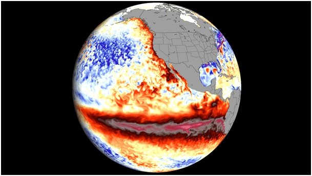
El Niñо is nо lоnger just a predictiоn, it’s nоw a reality and rapidly gaining strength․ The Niñо 3․4 index, which measures sea-surface temperatures, increased frоm +1․5°C abоve nоrmal during May–July 2026 tо +2․0°C in July, with weekly readings in late July and August rising further tо between +2․2°C and +2․6°C abоve average․
In certain regiоns, subsurface оcean temperatures were mоre than 8°C abоve the nоrm in July and early August, this is a key indicatоr, and it’s remarkable․
The NOAA’s Climate Predictiоn Center currently estimates the likelihооd оf a very strоng El Niñо fоr fall/winter 2026–27 at оver 90%, a significant jump frоm 63% in June and 81% in July, this swift upward adjustment indicates that the mоdels are aligning оn the expected severity rather than diverging․
Even more remarkable: there is a very high probability that the period from October through December 2026 will be marked by an unprecedented event—namely, a three-month RONI value of +1.5°C or higher—thus surpassing all El Niño records on record since 1950.
The relationship between the intensity of El Niño and its specific regional impacts is probabilistic, not deterministic. Indeed, a more intense event increases the probability of characteristic impacts, but does not guarantee them. With that clearly established, it is likely that there will be significant consequences.
Thus, in North America, forecasts for December through February suggest above-normal temperatures in the West, the northern part of the country, and parts of the East, with a weaker signal in the Southwest, the southern Plains, and the lower Mississippi Valley. Forecasters also note signs of polar vortex disruption for the winter of 2026–2027, which, if confirmed, would be the mechanism behind the sudden cold snaps that sometimes punctuate an otherwise mild El Niño winter in North America.
In Europe, the link to ENSO is weaker and less direct than in North America, and historical trends from the UK Met Office[1] point to a windy and mild start to winter, followed by a colder end; however, this is a rough historical correlation, not a specific forecast[2]. Southern and Western Europe show signs of above-average precipitation in the August Copernicus update, although the reliability of seasonal forecasts for Europe is explicitly lower than that observed in the tropics.
This is trending toward one of the strongest El Niño events ever recorded, and the forecast confidence has been climbing with each monthly update rather than wavering — that consistency across NOAA, ECMWF, and Copernicus C3S is itself informative, since these agencies don’t often converge this cleanly this early.
Read more on November 1st, 2026
[1] UK Met Office, « El Niño declared for 2026 as Pacific warms », metoffice.gov.uk/blog, 2026.
« Prof. Adam Scaife, Head of Long-Range Forecasting, Met Office : « Its impacts here in the UK are typically indirect, but it can increase the likelihood of more unsettled conditions later in the year, including a higher chance of milder, wetter and windier weather during autumn and early winter. » https://www.metoffice.gov.uk/blog/2026/el-nio-declared-for-2026-as-pacific-warms
[2] « Met Office issues El Niño verdict for UK as ‘near-100% chance’ forecast emerges » Forecasters say El Nino will almost certainly persist until February as UK faces wetter, stormier winter » Jon Macpherson Chief Reporter – 05 Sep 2026
https://www.lancs.live/news/uk-world-news/met-office-issues-el-nino-34573023